
What does your land actually look like?
We map the physical shape and contours of your property—capturing elevations, slopes, high and low points, mature trees, and natural drainage patterns. It provides the precise, baseline site data your architect or engineer requires to build a flawless design and secure smooth municipal approvals.
A map of the ground itself.
A topographic survey records the true shape and contours of your land. We measure precise spot elevations across the property and draw clear contour lines that show exactly where the ground rises and falls. Then, we map the exact locations of everything sitting on the surface: buildings, driveways, utilities, and drainage systems.
Your architect or engineer needs this detailed data before they can start designing. It tells them how water flows, where the terrain is steep, and what structures already exist—ensuring the custom plan they draw fits your site perfectly instead of fighting it.
A real sample, in full color.
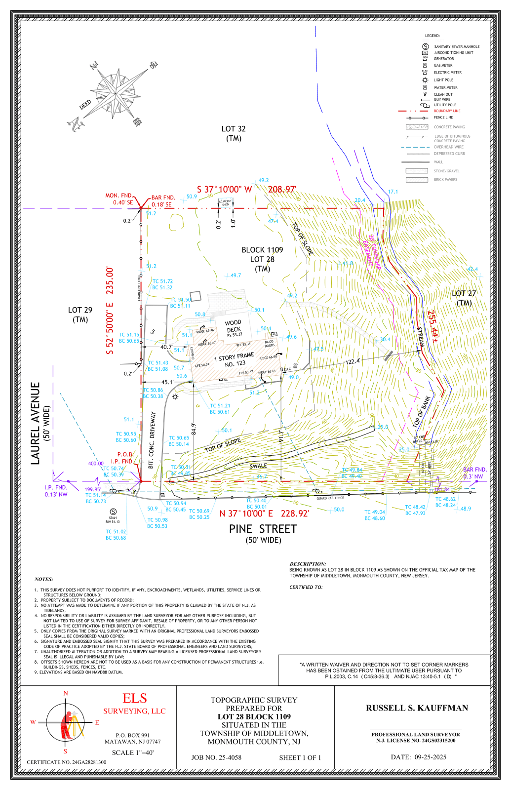
A real ELS topographic survey, with contours and elevations rendered in clean, legible color.
View the full sample (PDF)Opens in a new tab.When a topographic survey is the one you need.
Designing an addition or a new home
Architects start from existing grades. An accurate topo keeps the design buildable and the foundation sitting where it should.
CommonAdding a pool, patio, or driveway
Knowing the slope shows how the new feature drains and whether the site needs grading before work starts.
CommonSolving a drainage or grading problem
If water collects in the wrong place, contours show why and give an engineer the data to fix it.
CommonSubmitting a site plan to the town
Many municipal applications require existing-conditions topography before they will review the plan.
Time-sensitive
Everything that comes with a topographic survey from ELS.
- 1A color drawing with contour lines at the interval your engineer or town requires.
- 2Spot elevations across the site tied to a known vertical benchmark.
- 3Existing features located buildings, drives, walks, utilities, and visible drainage.
- 4Tree location as an add-on with size and species noted when your plan calls for it.
- 5A digital file for your design team with signed release form.
Survey data your design team can build on.
We shoot precise elevations in the field using our own dedicated crews and equipment, ensuring your engineer receives definitive numbers they can trust—never rough estimates.
The final drawing is delivered in high-resolution color, featuring clear contours and spot shots that an architect can read at a glance and seamlessly import directly into their base file without any tedious reformatting on their end.
Our support does not stop at the first delivery. If your design team requires an extra site detail or a tighter contour interval down the road, you will hear back from us the very same business day. We proactively keep your project file open until your design phase moves forward smoothly.
From site visit to a base your design team can use.
Request a quote
Send the address and what you are planning. We will reply within one business day
Field work
Our crew shoots elevations across the site and locates all existing aboveground features.
Drafting and review
We draft the survey in color, and a licensed PLS checks every detail before it is signed and sealed.
Delivery
The signed and sealed drawing will be sent to you and your engineer and/or architect.
Topographic survey questions, answered.
Request a quote in under two minutes.
Send the property address, the type of survey you think you need, and a closing date if there is one. We’ll come back within one business day with a flat fee and a target delivery window.