Where does your property end?
We locate every line and map every detail to deliver a certified survey that closings, fences, and legal disputes can all be built on with absolute certainty.
What you're actually buying.
A boundary survey answers one critical question: where does your property legally end? We research your deed and filed maps, then conduct onsite fieldwork to measure the precise dimensions of your lot.
When we finish, you receive a crystal-clear drawing of your exact property lines—providing a definitive legal document that a fence contractor, a title company, and a neighbor can all point to and agree on.
A real sample, in full color.
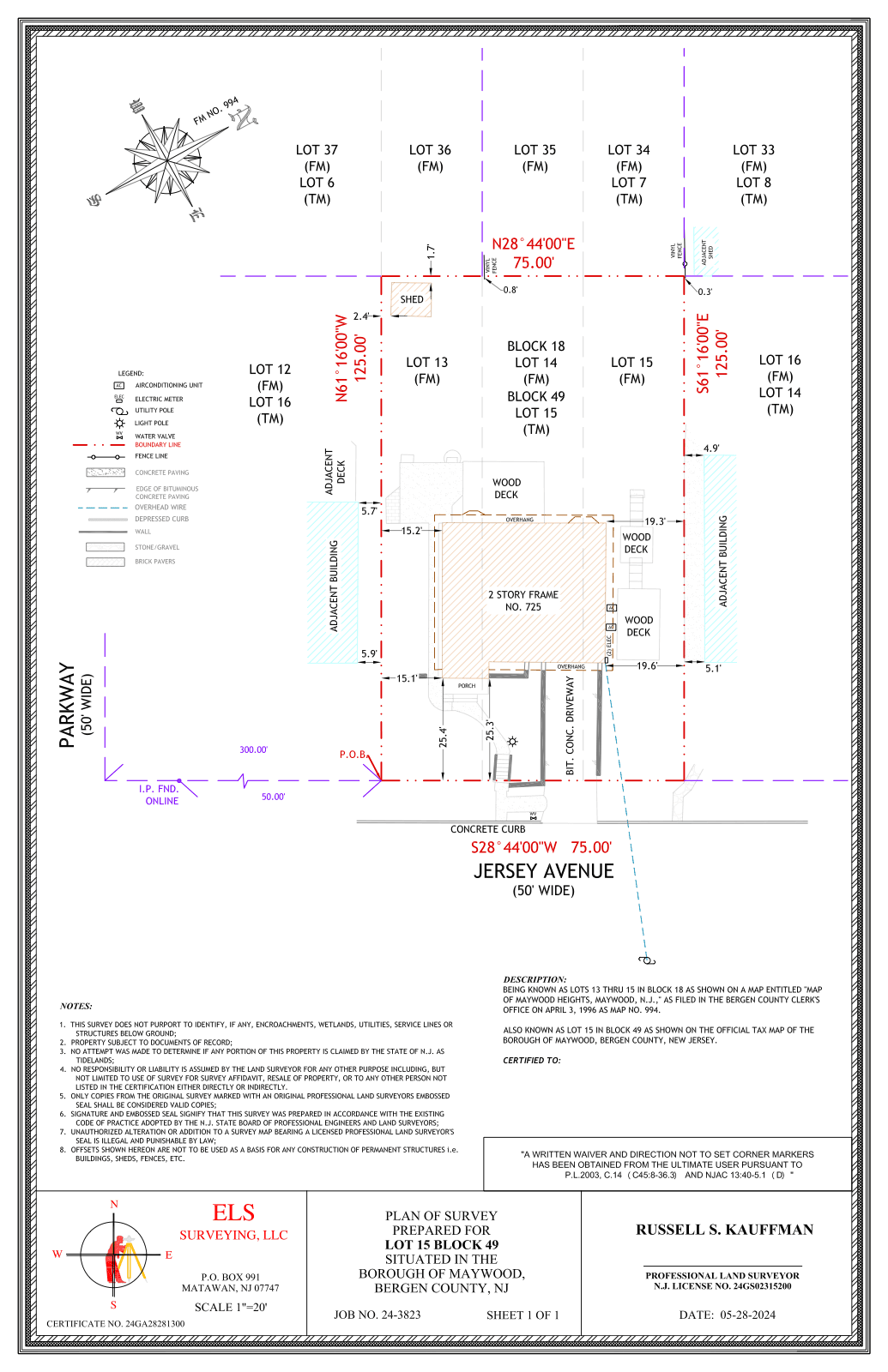
A real ELS boundary survey, signed and sealed by a New Jersey PLS and delivered in full color.
View the full sample (PDF)Opens in a new tab.Five reasons people order a boundary survey.
Buying a property
Most lenders and title companies require a current survey on file before they will clear a file for closing.
CommonBuilding a fence, shed, addition, or pool
Knowing the exact location of your property line keeps your new structure from encroaching on to your neighbor and assures you are within the setback the town may require.
CommonSelling your home
A clean, clear survey keeps your closing on schedule the moment the buyer’s lender demands official proof of the property lines. Avoid last-minute closing delays with a certified map that leaves zero room for underwriter doubt.
Time-sensitiveA line dispute with a neighbor
A signed and sealed survey settles where the property line actually runs, with an option for corner markers to bet set so both sides can see.
CommonSubdividing or filing with the town
The municipality needs an accurate survey before it will review a subdivision or issue a permit.
Time-sensitive
Everything that comes with a boundary survey from ELS.
- 1A color survey drawing with line weights and a legend you can read without a translator.
- 2A legal description prepared when your closing or filing calls for one.
- 3Direct delivery to your title company or attorney, sent straight to the file.
- 4Revisions within one business day on any open item before closing.
Color on the page, follow-up on the file.
Every boundary survey from ELS is delivered in vibrant, high-resolution color, using distinct line weights and a straightforward legend that any homeowner can easily follow. It is the exact same drawing that holds up under close scrutiny when an attorney reviews it with a client or a title officer files it for closing.
Because every single measurement comes entirely from our own dedicated crews and our own advanced equipment, our boundaries stand firm even if another firm tries to re-shoot them later.
We match that technical precision with relentless speed. When a title company needs a revision two days before a major closing, you will hear back from us that very same morning. We proactively track every open item until the survey is signed, sealed, and in the hands of the people who need it. From the field to the closing table, nothing goes silent.
From quote to closing in under two weeks.
Request a quote
Send the address and a closing date. We reply within one business day with a flat fee.
Site visit and field work
Our crew locates every boundary line and every property corner using our own equipment.
Drafting and review
We draft the survey in color, and a licensed PLS checks every property line and every detail before it is signed and sealed.
Delivery
The signed and sealed survey goes straight to your title company and attorney.
Boundary survey questions, answered.
Request a quote in under two minutes.
Send the property address, the type of survey you think you need, and a closing date if there is one. We’ll come back within one business day with a flat fee and a target delivery window.